From Bethlehem to Jericho by foot
As we hiked the Abraham Path, I realized that every step was inescapably political.

I arrived in Jericho the day before residents of the small Bedouin community at Khan al-Ahmar were required to vacate their homes so that the Israeli government could carry out its planned expansion of Highway 1. The village is one of the only remaining Palestinian areas within what Israel designates as the E1 zone of the West Bank, which bisects the northern and southern parts of the territory. Israel wants the highway to link East Jerusalem with the Jewish settlements of Kfar Adumim and Ma’ale Adumim. Critics say the ouster of the Bedouin community and the expansion of the highway will split the West Bank and make the prospect of a Palestinian state even more remote.
As it turned out, the deadline passed with the Bedouins still in their homes and the bulldozers quiet. But in protest of the anticipated destruction of the village, residents of the city of Jericho were on strike.
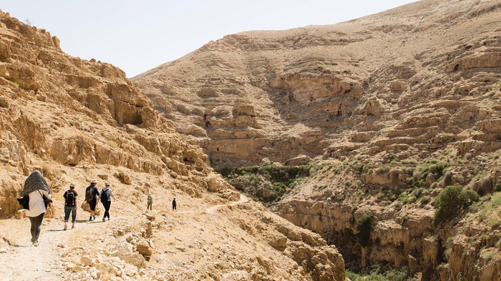
My husband and I arrived in Jericho on foot via the Masar Ibrahim, or Abraham Path, which runs from the north of the West Bank to the south. Hikers who complete the entire trail typically begin in the north West Bank village of Rummana and end southwest of Bethlehem near Hebron. We chose to hike a section of the trail in the opposite direction—from Bethlehem to Jericho. Our journey began behind the security wall near Bethlehem, where we passed a huge red sign that said in Hebrew, Arabic, and English: “The Entrance for Israeli Citizens Is Forbidden, Dangerous for Your Lives, and Is Against the Israeli Law.”
Read our latest issue or browse back issues.
Our guide, George Gacaman, was from an organization called the Siraj Center, located in Beit Sahour, just east of Bethlehem. George said he came from a family that had come to Palestine from Italy during the time of the Crusades and stayed. As he led us through Bethlehem, he showed us the shop where his grandfather had once sold cosmetics and another shop his father had owned. Both were shuttered. He showed us a string of woodworking shops owned by his cousins and a furniture shop where he worked with his family when not employed as a guide. Though 70 percent of all Palestinian Christians have emigrated over recent decades, a lot of Gacamans remain in Bethlehem.
The hike along the Masar Ibrahim was part of our longer engagement in alternative tourism in the region. We stayed in refugee camps and Bedouin guesthouses, not hotels. Instead of visiting the fourth-century St. Saba Monastery by bus, we traveled by foot. In many places around the world, alternative tourism simply means avoiding tourist traps and staying off the beaten path. In Palestine, we found, alternative tourism did not just mean traveling by alternative logistics. It means traveling by an alternative narrative.
Ayman Abu Alzulof, whom we met at the Alternative Tourism Center in Beit Sahour, told us that tourism in Israel is controlled by the Israeli government and designed not only to attract tourists to certain sites but to tell a certain story about the landscape. Both sides of the conflict understand the role that tourism plays in establishing a narrative about the land. Alzulof believes that this is why the Israeli government cares so much about who can serve as guides.
Alzulof said it is difficult for Palestinian guides to get licensed beyond the confines of the West Bank, and guides can lose their license if they offer any hint of a political critique. All tourism guides are licensed by Israel. Israeli guides are not allowed to work in areas of the Palestinian territories. Though some Palestinians are Christians, it is not easy for them make contact with Christian pilgrims, who make up almost 70 percent of Israel’s tourists. In 2009, the Israeli Ministry of Tourism deleted Palestinian territories and the West Bank from its tourism materials. Most Christians tour Israel with guides brought from abroad or with Israeli Jewish guides, which means Christians typically receive an Israeli version of events in which the Palestinian perspective is marginal. Alzulof said websites often suggest that travel to Palestinian areas is dangerous, and that makes his work difficult.
The Masar Ibrahim is a 330-kilometer trail that was begun in 1992, just before the Oslo Accords. The designers dream of expanding the trail so that it passes through Turkey, Syria, and Jordan as well as Palestine and Israel, but progress on that idea has been piecemeal. In addition to the Masar Ibrahim, the Siraj Center also promotes the Nativity Trail, an 11-day hike that begins in Nazareth and ends in Bethlehem.
Another trail in the region is the Israeli National Trail, which also runs roughly north to south but is nearly three times as long as the Masar Ibrahim. It skirts the West Bank on its way from the Israeli border with Lebanon in the north to the Gulf of Aqaba in the south. The Masar Ibrahim does not overlap with it, but it does pass through the Ein Prat Nature Preserve, a West Bank area controlled by Israel with Israeli-designed trails. According to George, the nature preserve decided it was too confusing to have both Palestinian and Israeli markers in the preserve, so it removed the Masar Ibrahim markers. For that stretch of the Abraham Path, we followed Israeli markers. George said that he and his fellow guides sometimes find their markers erased or defaced.
Being an alternative tourism guide puts George in an awkward position. On the one hand, he tries to stay clear of politics. “To live in peace in this area, you have to be away from politics, and this is what I am trying to do,” he said. “My job is not as a political guide.”
On the other hand, when hikers stand on a peak, look out over the landscape, and ask him what they are seeing, his answer is inescapably political simply by giving names to places. “I show facts which are in front of us during our hikes. We can’t avoid these facts.”
At one high place in the desert, we could clearly see the Jewish settlements of Kfar Adumim and Ma’ale Adumim southeast of Jerusalem. And although we couldn’t distinguish the tiny Bedouin village of Khan al-Ahmar, its place in the politics of the landscape was clear enough.
The night before we ended our hike on the Masar Ibrahim, we stayed with a small community of Bedouins similar to the one being threatened by bulldozers. It was not a peaceful night. Once the generator had been turned off, the dogs started barking, then the donkeys brayed, and about two in the morning the roosters started in, as if one moment of quiet was too much for them to bear.
On the wall of the small schoolroom that doubled as a guest room for hikers on the Masar Ibrahim was a map made by the West Bank Protection Consortium, an organization connected with the United Nations that tries to monitor human rights violations and protect fragile communities. The map showed the community in relationship to water sources, local leaders, and areas of “known settler violence.” This small community and its traditional way of life is threatened in several ways—by the highway that runs along its northern border, by the Israeli government making decisions 40 miles to the west, and by settlers who do not see the Bedouin way of life as worth preserving. “Alternative tourism” was one mechanism by which this community was attempting to protect itself.
I hadn’t intended to make a political statement by hiking the Masar Ibrahim, but I quickly learned that you can’t breathe or eat in Israel without making a political statement. If you think you can, you aren’t playing attention. By now I had passed by enough walls and barbed wire and military personnel with machine guns, seen enough graffiti, and talked to enough people that I understood something of where I was and what being there meant.
One day I took a bus from Jerusalem to al-Azariya (Bethany). On the way back to Jerusalem, Israeli soldiers took nearly everyone off the bus and lined them up in a kind of wire pen under the hot sun. Only after I had gotten off the bus and lined up with everyone else did I realize that I hadn’t needed to: foreigners were not required to go through this ritual. But my unbidden solidarity did not go unnoticed by the soldiers, my fellow passengers, or the others who stayed on the bus. Everyone stared at me, while pretending not to stare. I was always saying something just by my presence on this or that bus or in this or that neighborhood.
At many stops along the way, I heard Palestinians offer a version of the following comment: “Ask any Palestinian if he would rather be under Israeli authority or the Palestinian Authority and he will tell you: Israeli. Why? Because you can have a normal life. You can travel. You can go with your family to the sea. We pay money to the Palestinian Authority, a lot of money, and we get nothing: no public health care, nothing.” These Palestinians think their life has deteriorated since the Oslo Accords of 1994, which they say led only to checkpoints, the loss of rights, and the building of walls.
As a Christian traveling through this land, I was part of a long history of finding Christian history in the landscape. Like all Christian pilgrims, I was following in the footsteps of St. Helen, Constantine’s mother, who set out in the fourth century to locate and commemorate Christian sites. Most famously, she determined the site of Golgotha and the tomb from which Jesus rose from the dead. For 1,800 years pilgrims have followed her example, trekking around the Holy Land and trying to imagine what happened where.
Both Israelis and Palestinians I met told me there is no solution to the conflict unless the other party leaves the land entirely. With each recitation of their competing claims, the possibility of a workable peace seemed farther off. I know there are groups and individuals heroically working every day for better, more humane solutions. But they weren’t working in the places I visited. When I asked Alzulof about such groups, he said they exist but that they were not close to centers of power.
Jericho was quiet because of the strike. All the downtown shops were closed, except for the occasional bakery. At the guesthouse at the Aqabat Jaber refugee camp, the air conditioning and WiFi flickered in and out. Our host was a delightful woman named Um Fares, who decided that she would make us lunch rather than send us to a restaurant. After our long trek through the desert, it was a relief to sit still, even with the uneven air conditioning.
Our driver wasn’t sure if he should be driving during the strike, but he decided to take us to the Mount of Temptation anyway. Then he found us a cafe that was technically closed but willing to provide fresh-pressed juice for the four of us. We looked out over the Jericho plain and I tried to imagine the many different iterations of the city over the centuries.
When I returned to the United States a few days later, I had trouble finding out what had happened with the strike and the planned demolition of Khan al-Ahmar. As far as I could tell, the stalemate had continued. Bulldozers had pulled close to the site only to be met with Israeli, Palestinian, and foreign protesters. The police arrested four activists after protesters attempted to prevent the bulldozers from moving into the village. The Israeli military then surrounded the site and declared it a military zone. A day later, the Israeli government postponed demolition as it searched for a negotiated resolution.
The postponement was prompted in part by the intervention of Jewish leaders in the United States who urged Israeli prime minister Benjamin Netanyahu not to demolish the village. Demolition, their letter said, would “violate principles of human rights and humanitarian law . . . further hindering the path to peace and justice.”
A version of this article appears in the print edition under the title “The politics of a hike.”